Stamford:
The Development of an Anglo-Scandinavian Borough
Christine Mahany and David Roffe
The main purpose of this paper is to
illustrate those ways in which a detailed study of what is now a small market
town may be illuminated by the results of both historical and archaeological
analysis. Either approach, undertaken in isolation, would leave serious gaps in
our knowledge. On the historical side, the paucity of written evidence in the
two centuries before Domesday would bequeath but a sketchy insight into the
nature and topography of the early settlement. In archaeological terms, the
physical evidence which has emerged from excavation and topographical analysis
would be impossible to interpret taken alone. The integration of both
disciplines, however, makes it possible to present a fairly convincing picture
of the development of a Scandinavian and pre-Scandinavian settlement into the
Norman borough which it became. This is not to say that there are no problems
of interpretation, far from it, but that the questions become, by this
approach, easier to define, even if the answers remain stubbornly elusive.
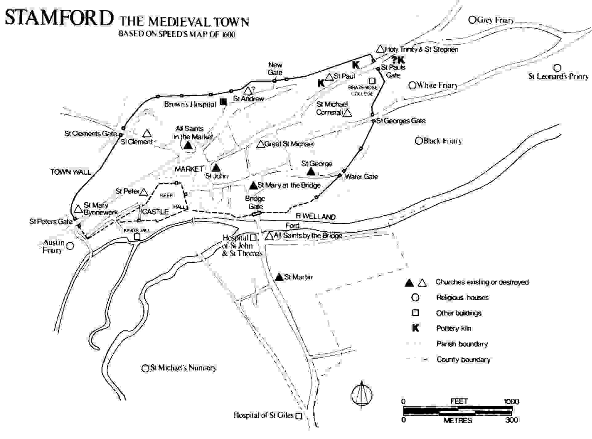
Stamford today is a small market town on the
north and south banks of the River Welland in South Lincolnshire (Fig. 1). It
lies in the promontory formed by the extreme south-western corner of the aptly
named extreme south-western wapentake of Ness. Before local government
reorganization it was flanked by Rutland to the north and west, and
Northamptonshire and the Soke of Peterborough to the south. The nucleus of the
settlement arose, and remained, on the north bank, but there was at least from
the tenth century onwards, a subsidiary settlement on the south in the region
which later became known as Stamford Baron. These two settlements are now connected
by a bridge, the latest successor of one deriving probably from the first half
of the tenth century. East and west of the bridge the limestone ridges on which
and of which the town is built diverge to give wide water-meadows upstream, and
gravel terraces downstream, which in prehistoric and Roman times supported a
scatter of rural occupation. Half a mile west of the town bridge Ermine Street
crosses the meadows by means of a ford, and it is from this that the place-name
"Stanford"—the stone ford—is derived.1
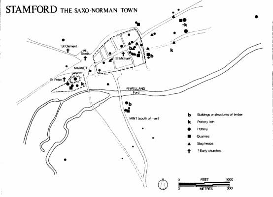
There is no evidence for any substantial
occupation in the Middle-Saxon or Roman periods. The site bursts into
prominence in the second half of the ninth century for two main reasons:
firstly as the center of production of an extremely fine wheelmade and often
glazed pottery, and secondly, and by implication, as a focus of Scandinavian
settlement. By the middle years of the tenth century we learn that Stamford is
one of the Five Boroughs of the Danelaw, with some unusual features not common
to the other four. In the succeeding two centuries the commercial life of the
town prospered, and it had grown by ca. 1250 A.D. into a mercantile center for
trade both local and international, taking its place as one of the foremost
boroughs of eastern England.
The first unambiguous documentary evidence
for settlement in Stamford comes from the Anglo-Saxon Chronicle, sub
anno 918, when we learn that "King Edward went with the army to
Stamford, and ordered the borough on the south side of the river to be built;
and all the people who belonged to the more northern borough submitted to him
and sought to have him as their lord."2 The relative positions of the two
boroughs are made clear in this passage, but the identification of their sites
has of necessity to rest very largely on the results of archaeological
investigation.
The earliest physical evidence for occupation
is provided by the discovery of the kilns and products of a late ninth-century
pottery industry. Prosaic as sherds are, they can give unsuspected illumination
to the historical record. The products of the kilns discovered on the castle
site are noteworthy and important for the fact that they display influences and
parallels with Northern France, particularly the Beauvais area. When one
considers the movements and inter-relationships of the Scandinavian armies in
England and France at this time, it is hard to avoid the conclusion that the
stimulus for the production of the Saxo-Norman pottery industries in such
places as Stamford and Thetford derives from the Danish armies and, in
Stamford, their French connections. If we indeed have a French potter working
in Stamford in the second half of the ninth century, it seems likely that he
came over with the armies, either as a commercial venture, or less voluntarily.3
In any case, it can be safely argued that the emergence of Stamford is closely
associated with the political, economic, and social revolution initiated by the
Danes; and the establishment de novo of Saxo-Norman pottery industries
in Danish foci can be seen as but one small indicator of the radically
new forces which were to transform the political and mercantile environment of
eastern England.
The rapid growth of the town in the first two
centuries of its history attests not only to its commercial success, but also
to its regional and at times national importance as a nodal point in the fluid
interplay of Angle-Scandinavian relationships. Stamford was never just a
settlement, to be regarded in isolation. The town must be seen right from the
beginning of its history in a wider context—in the context of the complex
territorial organization of which it was a part. Initially its importance was
probably derived from its strategic position. The detailed topography of the
site provided early settlers with a defensible position on a navigable waterway
to the North Sea, although the initial colonization derived probably from
landward expansion consequent on the division of the Mercian lands in the late
ninth century.4 Subsequently Stamford became an important link in a chain of
military centers which secured communication between East Anglia and the North.
Although in the early years of the tenth century the threat to such a center
must be thought to emanate from Wessex, it was not long before Stamford found
itself an integral though not frontline element in the protection of the
southern Danelaw against the north.
Its geographical situation, at the junction
of fenland to the east, the rich agricultural lands of Leicestershire and
Rutland to the west, the Lincolnshire heathlands and the forest of Rockingham
to the north and south, must have ensured its rise into a major center for
commerce, as it was for administration. These various factors, political,
military, administrative, and economic, ensured that Stamford emerged into the
eleventh century as a quasi county borough with a distinctive character
which although modified, survived the Norman Conquest.
The town is today, like all historic urban
centers, a palimpsest of its own history, and microcosm of its region. Only by
studying the one, can we hope to understand the other. Thus our analysis must
begin with an examination of the town itself. Initially the problem of the
location of the Danish Borough will be considered. We shall then examine the
development of the town and its role in the area, concluding with a
consideration of the consequences of the Norman settlement.
Stamford is apparently anomalous as a Danish
center. Unlike Lincoln, Leicester, Nottingham, and Derby, it has neither Roman
antecedents, nor extensive Middle-Saxon or non-Scandinavian Late-Saxon
settlement. However, as we shall see, the Danes did not find a tabula rasa,
but adapted their needs to a pre-existing territorial organization, which
survived the Scandinavian settlement and had a profound effect on the growth
and development of the town.
In considering the problems of the early
settlements, the starting point of our analysis must predictably be Domesday
Book.5 It is not without reason that Domesday studies have been likened to an
abstruse branch of nuclear physics.6 It is indeed possible, by means of
detailed procedural arguments and complex genealogical analyses, to reconstruct
the institutions of the town and to provide a detailed but somewhat
impenetrable topographical description.7 But that is not strictly germane to
our purpose. Rather, our analysis must be selective and more generalized.
Firstly, we must consider that situation which obtained before the coming of
the Danes; what elements, if any, might be identified as having an archaic character,
essentially an Anglo-Saxon character; and what, if any, is the archaeological
or topographical evidence to support it.
The most obvious observation to make is that
the text of the account of Stamford is divided into two parts.8 These relate
broadly to what have been termed customary, and non-customary, tenements.9 The
first section is concerned with those messuages which paid all customs to the
king. It also includes certain privileged townspeople. These are the Abbot of
Peterborough, who received toll and land-gable from the sixth ward of the town
beyond the bridge, which otherwise rendered all custom; and the 77 sokemen
"who have their lands in demesne, and seek lords where they will; over
whom the king has nothing except the fines of their forfeiture, and heriot, and
toll." The second is also concerned with more privileged tenements which
were to a greater or lesser degree quit of custom. It includes the land of the
lawmen, who had sake and soke over their own houses and their own men; land
which belonged to contributory manors; two churches which were in various ways
quit; and the estate of Queen Edith "which belonged to Roteland."
The essential difference between these two groups is not one of tenure or
status - for both are heterogeneous—but one of sake and soke, that is, the
interception of regalian dues. The sokemen may be privileged, but they are
still in the king’s soke, and no one but themselves benefits from their
exemptions. In the second section, however, royal dues are siphoned off by various
lords and they themselves are responsible for their tenements and men through
rural manors or otherwise. Their estates are thus not an integral part
of the king’s borough.
The point is crucial, for it casts much light
on an anomalous and important entry in the second section.
Queen Edith had 70
messuages which belonged to Roteland, with all customs except those
touching bread. To these [messuages] belong 2½ carucates of land, and 1 plowing
team, and 45 acres of meadow outside the vill. Now King William has [it] and it
is worth 6 pounds. T.R.E. they were worth 4 pounds.10
This estate is unusual. It is three times
larger than any other estate, comprising one-fifth of all recorded tenements in
the town, and as much as five-sixths of the carucated land. Unlike most of the
entries in section two, it did not belong to a "contributory" manor.
It was part of the royal estate of Roteland. This estate was somewhat
akin to a shire, and included many important royal manors, such as Oakham and
Hambleton.11 Its inclusion in the second section suggests that the diversion of
custom is at the essence of its status, and this is confirmed by the record of
a value. Valuits and valets are extremely rare in the
descriptions of Danelaw boroughs, for urban holdings are usually either, as
customary, valued en bloc within the borough or, as non-customary, in
the manor to which they belonged. But the formula has a specific significance
in circuit 6 of Domesday Book as a whole; it generally indicates the point at
which dues are collected, and is intimately connected with the term manerium.
This term, in itself closely related to the term aula, hall, indicates
the point at which dues, soke or custom, are intercepted.l2 The customary nexus
of Queen Edith’s estate in Stamford, then, appears to be not a rural manor, nor
the king, but the tenement itself. In other words, the estate is a manor.
In 1066, then, Queen Edith’s fee was a manor
located close to the borough, but not part of it. This estate was a very
ancient feature of the town. Crucial evidence is provided by the church of St.
Peter (Fig. 1). The Domesday Book entry is as follows: "Albert [had] one
church, [that] of Saint Peter, with 2 messuages, and half a carucate of land
which belongs to Hambleton in Roteland. It is worth 10
shillings."13 Albert is Albert of Lotharingia, a churchman of some
importance before the Conquest, who nevertheless managed to maintain his
position in the reign of King William.l4 His fee in Roteland was made up
of the churches of Queen Edith’s manors of Oakham, Hambleton, Ridlington, and
St. Peter’s in Stamford.15 Just as his church of Oakham was the church of Queen
Edith’s manor in that settlement, so it seems likely that St. Peter’s in
Stamford was the church of her manor there. If we accept that churches and
manorial halls were usually closely associated, the site of St. Peter’s church
may give some indication of the nucleus of Queen Edith’s extra-burghal
estate.16 If we accept such a nucleus—and the site of St. Peter’s church is
known and exists as a grassy knoll just west of the castle motte—we can begin
to ask questions about the extent of the fee.
The church and manor between them possessed
all the carucated land in Stamford, altogether some three carucates, which
suggests a considerable amount of land within the context of Roteland.
This impression is reinforced by an examination of the ecclesiastical parishes,
in origin closely related to the area of estates (Fig. 2). In the nineteenth
century, before enclosure, almost the whole of the fields of the town were in
the amalgamated parishes of All Saints and St. Peter.17 It is not now possible
to disentangle the lands of each, but Stukely recorded the tradition that St.
Peter’s had large parochial precincts, which he used as an argument to
demonstrate that it was the first church of the town.18 We can confirm that the
church had indeed extensive glebe in the West Field of Stamford, and that its
parish covered a large area of the common fields.19 Other parishes, those of
St. Mary Bynnewerk, and the pre-Conquest St. Clement, were probably carved out
of this territory.20 The original parish of All Saints is unknown, but was
probably substantially a now detached portion of the present parish, enclosed
within the bounds of St. George. The likely size of the parish of St. Peter
tends to support the suggestion that it was the "mother" church of
the town, and this in turn would suggest that the estate associated with it is
primary.
Two independent categories of evidence,
archaeological and topographical, support this conclusion by indicating the
primary nature of the St. Peter’s church nucleus. Immediately to the south and
east of the site of St. Peter’s church lies an area which came to be occupied
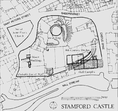
by the Norman castle. It is from here that the earliest evidence for occupation
in Stamford comes. During the excavation of the castle, a number of very much
earlier features came to light. In particular part of a double-ditched
enclosure with an internal palisade was found (Fig. 3). Badly disturbed to the
west and east, the enclosure could nevertheless, if produced, have encircled
the knoll on which St. Peter’s church had stood. There is evidence that it was
in use for only a short time, for at least part was quickly back-filled.
Clearly it was either defensible, or a very well-marked boundary.21 In the
filling was a coin of Alfred, and intimately associated with the outer ditch were
pottery kilns dated archaeomagnetically to the second half of the ninth
century.22 The nature of the occupation contained within the ditched circuit is
unknown, but the possible association of an early church of a royal estate with
a palisaded enclosure, may suggest the presence of an aula. Whatever its
function the importance of the site is evident, and its primary nature is
supported by the second category of evidence, the topography of the town.
Figure 3
The present bridge across the Welland is a
nineteenth-century structure, but part of the stonework of a twelfth-century
predecessor survives to this day.23 It would be surprising, however, if there
were not antecedent structures considerably earlier than that. King Edward the
Elder is the most likely candidate as our first bridge-builder, for it was he
who bridged the Trent at Nottingham, in an effort to integrate his two boroughs
there, and it seems inconceivable that he would fail to link the similarly
placed boroughs in Stamford, on either side of the infinitely more
insignificant stream of the River Welland.24
The route to the bridge from the south
appears to be a divergence from a more direct, and possibly earlier route, the
causeway across the meadows (Fig. 4). This latter route links with Castle Dyke,
which marked the eastern extremity of the castle, and the parish boundary
between All Saints/St. Peter and St. John. We shall return to the Edwardian burh
and to the river crossings, but for the moment it is sufficient to note that if
the bridge is as early as 918, and if the causeway antedates it, then the fact
that the causeway connects with the area round St. Peter’s, may be some
indication that the occupation of this region could go back to the late ninth
century, as does the pottery industry and the enclosure.
Figure 4
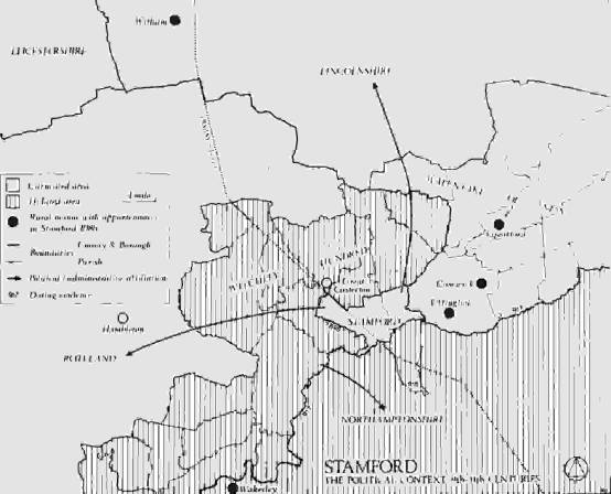
As we have seen, there is a close association
between the St. Peter’s/All Saints nucleus and Roteland. Phythian-Adams
has argued that the medieval county of Rutland, arising in the twelfth century,
recognized the integrity of a royal estate which split into two between 894 and
917 (Fig. 7).25 Witchley Hundred, immediately to the west of Stamford, was
appended to Northampton and appears under that heading in Domesday Book. The
wapentakes of Martinsley and Alstoe, the Domesday Roteland, maintained
their autonomy though they were subsequently associated with Nottinghamshire
for the purposes of the geld.26 Queen Edith’s 70 messuages were part of this
estate of Roteland and her title to this land in Stamford was clearly
derived from her title to the area as a whole. Since the fee would appear to be
primary to the town, it is thus likely to be a remnant of the larger estate of
Rutland before it split up. This estate was of considerable antiquity and was
probably of an archaic structure by the early tenth century, perhaps deriving
from Middle Saxon or earlier origins.27 In territorial terms, then, much of
what became the town of Stamford must have belonged to Rutland before the
Danish settlement. There is no archaeological evidence of a substantial, or
indeed any, Mercian settlement, but it seems clear that an ancient territorial
relationship was recognized and accepted by the Danes, for this estate was
evidently not part of their borough. This recognition is suggestive. The
existence of an early royal church, possibly associated with the palisaded
enclosure points to the importance of the estate and its survival suggests the
continuity of regalian functions throughout the political instabilities of the
Scandinavian occupation, and into the eleventh century when King William used
the same site for the establishment of his castle.
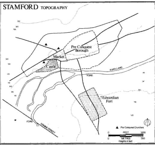
If this interpretation is correct, it is
clear that the Danish Borough must be sought elsewhere, but first it is
necessary to look briefly again at the burh of Edward the Elder, south
of the river (Fig. 5). The existence of a mint, or at least a moneyer, in this
part of the town together with the place-name Burghley, borough-wood,
immediately to the south-east of High Street Saint Martins, suggests the
existence of something more than a marching camp.28 The location of the site is
fraught with problems. It is likely to have commanded the river crossing,
either the causeway mentioned above, or the ford which still exists just
downstream of the present bridge. It is possible to see High Street Saint
Martins as the axial road of a planned complex, post-dating both ford and
causeway The northern limit is perhaps indicated by a curve in the road twenty
yards south of the bridge, the eastern and southern boundaries by lanes, and
the south-east sector by a parish boundary. A ditch antedating a Saxo-Norman
quarry was found on the proposed line, just west of Burghley Lane. The area
encompasses the limits of settlement to the south-east and west in the twelfth
century, and its axial road is marked by the two churches of St. Martin and All
Saints-by-the-Water, the latter possibly a pre-Conquest foundation.29 This
represents, from all available evidence, not forgetting the distribution of
pottery, the most likely site for Edward’s burh.
Figure 5
Looking now to the north of the river, we
must consider the site of the Danish Borough which Edward found when he came to
Stamford in 918. There are several ways of looking at this problem, but
fortunately the various strands of evidence all point in approximately the same
direction. They suggest the establishment of a planned town to the east of the
All Saints/St. Peter’s complex, and antedating the bridge.
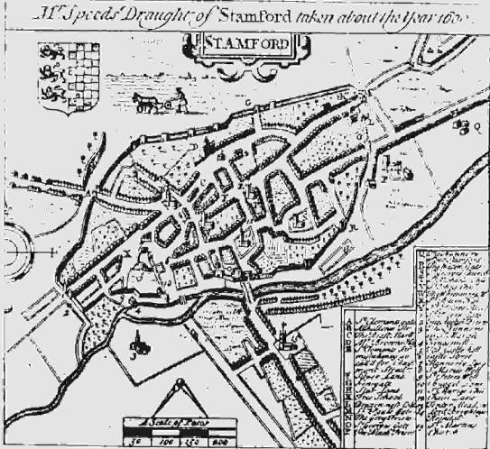
Our earliest map is that of John Speed (Fig.
6) of the early seventeenth century. From it we can see that the street-plan of
the town has changed hardly at all in the last three and a half centuries, and
we are thus able to draw to a modern scale (Fig. 1) a base-map incorporating
those elements which Speed represents. The next step is simply to subtract from
the plan known late features, such as the medieval town walls and the
extra-mural roads (Fig. 4). We are left with what appears to be a planned
nucleus, separated from the castle by a market; in other words exactly what one
would expect. As we have seen from the historical evidence, we would predict
that the borough would not be in the region of St. Peter’s church, nor is it.
It is sited on an adjacent spur overlooking the narrowest part of the river.
The detailed topography supports this interpretation and has been extensively
argued elsewhere.30 Briefly, there is the matter of the dog-leg performed by
what was the Great North Road on its route from the town bridge to the market
place by All Saints, which suggests that it is skirting a pre-existing complex.
Both the street plan and the pattern of tenement plots tend to confirm the
suggested nucleus.
Figure 6
The opportunity arose in 1969 to excavate a
small site just east of St. George’s Street, where a possible defensive system
might be expected. What was found was indicative of a system of upright and
horizontal timbers rather similar to what had been discovered a few years
previously on the defenses of the Æthelflædian burh of Tamworth. Another
excavation in the very center of the proposed borough revealed traces of flimsy
timber buildings sited end-on to the High Street—the beginning of a long
sequence of occupation on the site. In both cases archaeological evidence
suggested a date towards the beginning of the production of Stamford ware, that
is the late ninth or, more probably, the early tenth century.31 The evidence
from parish boundaries, as argued by Alan Rogers, tends to support an early
nucleus on the site we have suggested.32
We are left then with what appears to be a
sub-rectangular early nucleus with High Street as its east-west axis. The
western prolongation of High Street joins with the All Saints/St. Peter’s
nucleus which we have already suggested antedates the borough, and it may be
that this road, too, is earlier than the Danish settlement and was simply
utilized in its planning (Fig. 5).
Topographically, our planned area would
appear to predate the complex south of the river, if we believe the latter’s
axial road to be aligned on the bridge. The archaeological record, then, so far
as it goes, supports the 918 annal, and also the arguments from Domesday Book
as to the siting of the Danish Borough. The discovery of sherds of Stamford
ware deriving from the castle kiln under the eastern defenses of the proposed
borough indicate too that the planned settlement post-dates, if only by a
little, the establishment of the pottery industry, and by implication, the
digging of the ditched enclosure on the castle site (Fig. 3).33 Whether the
Danes were responsible for this minor fortification, or whether it was an
essentially Mercian manifestation remains unknown. What is likely is that the
Danes took over the site, incidentally establishing a pottery industry there.
But their main center of activities was on a similar knoll further to the east,
where a fortified borough was established in the years preceding 918. This
planned borough was distinct from the estate of Roteland to the west,
and may have been associated, as we shall see, with the areas of Kesteven and
Holland to the north-east.
We have dealt at some length with the detailed
topography of the town because this is an essential preliminary to considering
its role in the region. We now come to the very important matter of attempting
to place Stamford in its wider context, and the next section is devoted to a
consideration of its territorial affinities in the years preceding the Norman
Conquest.
An essential element in the functioning of a
Danelaw, or indeed a Wessex borough, was the territory which it could look to
for its sustenance and support, and for Stamford this presents unusual
problems. In the case of all the other members of the confederacy of the Five
Boroughs, the burghal territory became rationalized into the institution of the
shire. Such was not the case with Stamford. Various references have indeed been
adduced to prove that "Stamford-shire" formerly existed, but all the
sources are unreliable or of dubious authenticity.34 Moreover the term
"shire" in the context is probably anachronistic. C.S. Taylor has
argued that the institution of the shire with its separate royal administration
was introduced into Mercia in the early years of the eleventh century in
response to the need to marshal resources to counter the renewed Danish
attacks.35 At this time Stamford was indubitably part of Lincolnshire. The
annal for 1016 illustrates that the town was on the boundary between
Lincolnshire and Northamptonshire and the pattern of administration as revealed
by carucation, shows that it was an integral part of the former.36 The notion
of "Stamford-shire" is therefore inappropriate since the town was
already attached to Lincoln at the time when the institution of the shire as we
know it was introduced.
But this is not to say that Stamford did not
have a tributary territory before this period. Although it has been argued that
all ties at this time were of a personal nature, and that territories were not
defined, there must nevertheless have been a relationship between the town and
the area required to produce the numbers necessary to support it.37 The
intimate relationship between burghal hidage assessments and the defenses of burhs
suggests a high degree of territorial organization in the early tenth century
in Wessex and beyond.38 There are clues to suggest a similar organization in
the Danelaw. Thus the 917 annal records that Northampton submitted to Edward
"with all those who owed allegiance to it as far north as the
Welland," while the Florence of Worcester version of the 918 annal records
the submission of the more northerly borough at Stamford "and all those
who owed allegiance to it."39 These and similar references, although not
without their difficulties, suggest that there were areas which were dependent
on central boroughs.40
The location and extent of the territory of
the borough of Stamford can be suggested with some precision. An examination of
the boundaries of Stamford shows that its topographical anomalies betoken a
second phase in the organization of territory. The fields of the town overlie
an earlier division of land within the ancient estate of Rutland, and form an
integral part of the wapentake of Ness (Fig. 7).41 This latter term is probably
used in an administrative rather than a topographical sense, and it would
appear that the town was deliberately appended to it at the time when the
earlier division of land was disrupted.42 The town therefore looked to the east
for its territorial context at a time when its boundaries were first defined.
Twelfth-century evidence exists for several points along its line, and since
the town is situated at the boundary between hidated and carucated England, the
date of carucation provides a terminus ante quem for its whole course.43
This cannot be later than the early eleventh century. If, as there is evidence
to believe, carucation is as early as the mid-tenth century, then Stamford must
have been associated with land to the east, which was later part of
Lincolnshire, at the same time.44 However, an earlier date still is indicated
by the Chronicle evidence. In 917 the territory of Northampton extended
up to the Welland, and probably also included Witchley Hundred north of the
river and to the west of the town.45 In 894 the territory to the west of
Stamford was distinct and possibly hostile. Æthelweard records that in that
year "the Danes possessed" (according to Campbell) or "were
ravaging" (according to Stenton) large territories in the kingdom of the
Mercians on "the western side of the place called Stamford."46
Figure 7
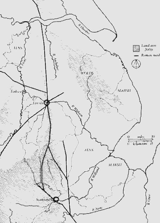
It seems therefore that from 917 the
territory of Stamford must have lain to the east and north. Its northern limit
is almost certainly indicated by the southern extent of the kingdom of Lindsey,
with which Lincoln was intimately associated (Fig. 8). Stenton has argued that
the Ridings of the division and its "island" topography indicate that
it was in existence in the early Danish period, and it is probably coterminous
with the earlier kingdom.47 The contributory manors of Lincoln itself, where
discernible, are all in the area and the division between Lindsey and south
Lincolnshire marks a very pronounced tenurial boundary in the mid-eleventh
century.48 No western limit can be suggested unless carucation was as early as
the mid-tenth century. If this was the case, then Stamford was closely
associated with the area of Kesteven from this time, for it was an integral
part of its local government apparatus.49 This area was, like Lindsey,
topographically discrete. Holland, to the east, was equally isolated, but was
almost certainly associated with Stamford. Its lines of communication are
mostly through Kesteven, and procedurally it was part of that division when the
Lincolnshire Domesday was compiled.50 Moreover the customs of king and earl in Sudlincolia,
that is Kesteven and Holland, were rendered together amounting to £28.
Significantly, Stamford is said to have rendered exactly the same sum, and it
is possible that the two figures are one and the same render.51 We may conclude
then that the territory of Stamford extended from the Welland to the Witham.
Thus Lincoln and Stamford were situated on the peripheries and to the south of
their regions, so that they could control the entrances to the two areas,
commanding the main lines of communication between the Danish colonies in the
north, and the southern Danelaw and East Anglia.
Figure 8
By 1014 Stamford had lost its territory and
was part of Lincolnshire. Loyn has argued that it was appended to Lincoln in
the late tenth or early eleventh century, consequent upon the renewed
Scandinavian attacks from the north.52 The confusion in the Domesday sources
between the terms Lindsey and Lincolnshire suggests that the
politically dominant partner was, and the initiative for annexation came from,
Lincoln.53 Indeed a very heavy tax assessment was imposed on Kesteven and
Holland when compared to Lindsey.54 But it is possible that close ties between
Stamford and Lincoln may be of an earlier date. If carucation can be dated to
the mid-tenth century, the two boroughs are closely associated at this period
as part of the confederacy. A common quota was imposed on both areas, and this
suggests a common authority.55 Again, if, as suggested by Hill, the Minster of
St. Mary, Lincoln, was built in the mid-tenth century, then the extent of its parochia,
the later county of Lincoln, may suggest that Lindsey and Kesteven were closely
associated at the time of its foundation.56 It was precisely now that the
threat to peace also came from the north, and the evidence of the 942 annal
would suggest that the northern Danelaw was hostile to the Norwegian kingdom of
York.57 It is probably no coincidence that we first hear of the Five Boroughs
at this time.58 By the time of Æthelred they were organized as a confederacy
with a common assembly, perhaps to control a buffer zone set up after the
redemption as a marcher area against the north.59 It is perhaps within this
context that we ought to understand the reorganization of territory. Lincoln
was a forward position, and Stamford and its territory became appended to it,
with a penal tax assessment, to support it. Nottingham and Derby were probably
grouped in the same way, for the two counties were very closely associated from
the time of carucation.60
The next major change in Stamford comes of
course with the Norman Conquest. The town on the eve of the Conquest was a
heterogeneous mélange indeed. Both boroughs, north and south of the river, had
by this time spread beyond their original bounds. Thus there were suburbs
extending down to both banks of the river, and along most of the approach
roads. There was an industrial zone south and east of St. George’s Street,
where iron-smelting had spread outside the borough, and where the pottery
industry was flourishing. The old St. Peter’s nucleus was another suburb.61
As for what was going on on the castle site
we have no archaeological evidence. The area of the motte, now under a bus
station, has not been available for excavation. A shell-keep was destroyed, and
no doubt many underlying layers as well, in 1933.62 Once again we have to turn
to Domesday Book where we learn that five mansiones were waste on
account of the work at the castle, as compared with 166 at Lincoln.63 However,
strictly speaking this cannot be taken to indicate the level of land use before
the construction of the castle for it does not record the number of structures
which were destroyed. The term mansio may have a primarily legal
meaning, for frequently contrasted with domus, it refers to something
more than actual physical structures.64 Moreover, reference is only made to the
wastage of those mansiones which had formerly paid custom. Wastum
itself is a technical term. Although it must frequently imply complete
destruction of a tenement, nevertheless land could be waste, and yet still be
worked.65 It is clear in these cases that the term has the primary meaning of
loss of revenue. Thus in recording that five mansiones were waste on
account of the work of the castle, the commissioners were not noting the
destruction of five buildings, but the loss of revenue which had been owed to
the king from five ill-defined entities. Since, as has been argued, the castle
was situated in or adjacent to the nucleus of a large non-custom-paying manor,
many other mansiones and structures may have been destroyed but have
gone unrecorded since their destruction did not affect the total customs of the
town. The area south of the motte, which became the castle bailey, was
extensively excavated, but the slightly built timber structures which may have
existed on the site before 1066 were not found due to extensive later
stone-quarrying, and other disturbances.66 Even had they been found, they would
have been difficult to date, for it has often been said that in regard to
pottery studies, there is no evidence for the Norman Conquest at all!
Of the institutional framework found by the
Normans we know little, but we have speculated that the royal manor centered on
St. Peter’s maintained its integrity down to 1066. It was probably in 1068 that
the Normans chose the nucleus of that very royal estate as the site for their
new castle. The reasons for their choice were no doubt concerned as much with
military strategy and convenience, as with the conscious perpetuation of a
regalian function. Elsewhere they had few qualms about disturbing the status
quo. Certainly the military problems facing the Normans were not dissimilar
to those which the Danes had encountered some two hundred years previously.
Characteristically also, the rationalizing grip of the Normans can be discerned
in the manner in which they solved the problems posed by the antiquated and
absurdly anomalous tenurial and administrative arrangements of the town.
The existence of a castle is first recorded
in Domesday Book. It is likely that it was built in the early years of the
Conquest, for the Anglo-Saxon Chronicle records that the king "went
to Nottingham and built a castle there, and so went to York and there built two
castles, and in Lincoln and everywhere in that district."67 This was in
the spring of 1068. Florence of Worcester records that in the same year William
ordered a castle to be built in Lincoln after his return from York, and in
other places; while Orderic states that castles were also built at Huntingdon
and Cambridge.68 Although no specific reference is made to Stamford, it seems
likely that it was similarly fortified at this time, since the king seems to
have been concerned not only to secure important centers of population but also
the main roads to the north, a region he had failed to rule through native
leaders. The 1068 campaign was designed to dissociate Mercia and Northumberland
and prevent an alliance which had troubled King Edward in 1065. It was also
intended to be the instrument of introducing Norman rule to the north.69 At any
rate, by 1070 the Normans evidently considered the town to be safe, for
Thorold, the newly appointed Abbot of Peterborough, took refuge there with 160
men, while Hereward ravaged his monastery.70
The site of the castle, adjacent to the
Danish Borough and on a neighboring knoll, must have been equally defensible
(Figs 4 and 5). The motte required little artificial heightening to enable it
to dominate the western approaches to the borough, the early river crossing
from the south, and a large triangular area between the borough and St. Peter’s
where there is evidence for a market from at least the twelfth century.
Superficially the topography suggests that the fortification fitted into the
classic pattern of castle, market, and town, which we see at Nottingham.71 This
impression is probably erroneous. Hoskins and Rogers have used a curious
reference to Portland in the Northamptonshire Domesday to argue that the
construction of the castle was linked with the creation of a Norman market
place between All Saints and St. Peter’s.
The king has in
his demesne of Portland 2 carucates and 2 parts of a third carucate of land and
twelve acres of meadow. One carucate belongs to the church of St. Peter, and
half a carucate to the church of All Saints. Portland with its meadow rendered
48s. TRE. . . .72
This entry is anomalous, since it is the only
parcel of carucated land in the whole of the Northamptonshire Domesday.73 Although
the place-name is not found after 1086, Portland can be confidently
associated with Stamford. It is a later but foreseen addition to the text, but
is grouped with those manors which were subsequently in the county of
Rutland.74 However, Portland cannot be a Norman innovation, for it is
given a TRE value. Moreover it cannot have been situated in the market place.
The two churches were not, as Hoskins and Rogers claimed, located in
Portland, indeed the use of the iacet ad formula implies quite the opposite,
but merely held land there. From the available evidence then, the construction
of the castle was probably not accompanied by major topographical replanning.
But the Portland reference does
provide an understanding of an associated reorganization of administration.
Since it is associated with the Rutland manors, it can be identified with that
part of Stamford which was in the same county in the later Middle Ages, namely
the hamlet of Bradcroft and the west field of Stamford.75 This was bounded on
the east by Ermine Street and was significantly known as "Sundersoken"—estate
apart. Both location and name suggest that Portland had formerly
belonged to an estate in Stamford, and, as non-customary land held by the king,
it is difficult to escape the conclusion that it formerly belonged to the only
royal estate of that kind in the town, namely Queen Edith’s fee. Domesday Book
significantly informs us that her 70 messuages belonged to Roteland,
that is, in 1066. In 1086, however, they were part of Stamford in Lincolnshire.
It can be suggested, then, that the Normans, faced with the need to build a
castle on land administratively not part of the borough of Stamford in
Lincolnshire, incorporated the urban element of the fee into the borough. At
the same time its agricultural counterpart was appended to the nearest royal
manor, either Great Casterton, or Ketton, in Rutland (Fig. 7).
The Portland reference, then, provides
no evidence for the status of the market place, still less that it is of
post-Conquest origin. On the contrary it is to be expected, given the probable
pre-Conquest foundation of All Saints, and the town’s burghal status from the
tenth century onwards, that a market place existed in the late Saxon period on
the very site proposed by Hoskins and Rogers, between All Saints and St.
Peter’s, that is from the Danish Borough to the possible royal aula
which could have provided its institutional basis. Thus the castle was probably
inserted into a topographical framework which had been established at least 150
years before its construction, and the administrative arrangements were
adjusted to accommodate it.
The later history of the castle is
inextricably linked with that of the town and its lords, though unfortunately
the first hundred years of its history are the most obscure, both in historical
and archaeological terms. No reference is made to its structure between 1086
and 1153, when it ultimately failed to withstand a siege from the forces of
Henry of Anjou.76 This was its only known military engagement. Writing in the
mid-twelfth century, the author of De Gestis Herewardi Saxonis, makes
mention of a Great Hall with an inner room, but this work is not the most
reliable of chronicles—Hereward is supposed to have been guided to Stamford by
a Wolf.77 As far as we know the borough and presumably the castle were in royal
hands until 1156.78 Unfortunately nothing is known of the role of the castle in
the administration of the town.
There is little evidence of how Stamford as a
whole fared during the troubles of the anarchy. Evidently the castle was in
some state of preparedness prior to the siege of 1153 and was able to resist,
at least for a time. The town capitulated immediately which may indicate lack
of defenses, or perhaps sympathy with Henry of Anjou. But the effect of the
anarchy on the town should not be over-estimated. The deficiencies of the
evidence do not allow an exact chronology of development, but evidently the
town had grown considerably by the mid-twelfth century.79 Its extent is
indicated by the evidence for the existence of churches, and surviving
twelfth-century architectural features.80 If the sites of the churches can be
taken as an indicator of urban development it is clear that there had been
considerable expansion in the hundred years after the Conquest. But by no means
the whole area had been built up: throughout the Middle Ages, there were always
open spaces within the town walls. Thus excavations on quite a large scale in
the area behind the town walls in West Street, revealed no trace of medieval
occupation whatsoever.81
The prosperity of the town was based on a
number of factors. Firstly, it was a local market for a rich agricultural area
with easy communications by water and road, and many religious houses acquired
land in the town. Secondly, the town was a center for industry. In the twelfth
century the pottery industry was still flourishing and continued to do so until
the mid-thirteenth century. The challenge of the cheaper but nastier rural
potteries had not yet been felt.82 Much more importantly, Stamford was the
center of production of a high quality wool cloth, which came to clothe some of
the highest in the land, as well as being exported as far afield as Italy.83
The export of raw wool was also a decisive factor in the town’s mercantile
success.84 Most of the evidence for Stamford’s trading connections comes from
the thirteenth century, but there is no doubt that this merely reflects the
later elements in a success story which began at least as early as the eleventh
century.
This paper is not of course concerned with
the thirteenth century, which is outside our terms of reference, but it is
worth observing that in Stamford, as in so many English towns, the thirteenth
century was the time when it took on the characteristics which we would
recognize today; it was a period of change, the substitution of stone for
timber in domestic building, in castle building the enlargement and
embellishment of existing structures, in church building, wholesale
reconstructions which quite sweep away any record of Norman predecessors, and
in mural building the reconstruction of the town walls in stone. On the
archaeological front there is a veritable explosion of evidence, as there is on
the historical. By 1250 the town had taken on the form which it had when Speed
drew his map in about 1600, and this is the Stamford which, despite more than
three centuries of piecemeal alteration, the observant eye can still, in 1982,
detect.
The purpose of this paper has been, not to
weave arabesques around a parish pump, but to serve as a plea for greatly
increased co-operation between the exponents of our two disciplines. It is
still unhappily not the case that every archaeological excavation is invested
with historical significance; nor unfortunately is it always true that the
historian welcomes the products of archaeological endeavor in a manner wholly
flattering to the excavator. Our hope is that by attempting to illuminate the
complexities attendant on the examination of a small town in eastern England,
we have demonstrated beyond reasonable shadow of doubt that there is no longer
any place for a compartmentalized approach to the study of the changing events
and landscapes of the past.85
NOTES
1. A.M.J.
Perrott, "The Place-Name Stamford," Stamford Historian 2
(1978): 38-40. The crossing to the east of the town bridge is identified as the
eponymous ford. However, in the light of possibly authentic notices of the
early use of the name and the development of the town, it is far more likely to
refer to the Roman ford.
2. ASC
66.
3. K.
Kilmurry, The Pottery Industry of Stamford, Lincs., c. AD 850-1250
(Oxford, 1980), 195; Kathy Kilmurry, "The Production of Red-Painted
Pottery at Stamford Lincs.," MA 21 (1977): 180-6, at 184.
4. Kilmurry,
Pottery Industry, 145.
5. DB
1, fol. 336d; The Lincolnshire Domesday and the Lindsey Survey, ed. C.W.
Foster and T. Longley, (Horncastle, 1924), 9-11. This latter edition (hereafter
Lincs. DB) is used for Lincolnshire references to facilitate the
identification of individual entries.
6. Apud
signum scaccorum ad Bellum festo Sancti Jacobi anno regni regine Elizabethe
secunde trecesimo prime superauditum.
7. For
the general method, see D.R. Roffe, "Rural Manors and Stamford," South
Lincolnshire Archaeology 1 (1977): 12, 13.
8. Lincs.
DB, 9/1-4; 9/5-11/16.
9. J.
Tait, The Medieval English Borough: Studies on its Origins and
Constitutional History (Manchester, 1936), 89.
10. Lincs.
DB, 11/9.
11. Charles
Phythian-Adams, "Rutland Reconsidered," in Mercian Studies,
ed. Ann Dornier (Leicester, 1977), 63-84, at 64.
12. D.R.
Roffe, The Making of the Lincolnshire Domesday, in preparation; F.M.
Stenton, Types of Manorial Structure in the Northern Danelaw, Oxford
Studies in Social and Legal History 2 (Oxford, 1910), 32-4.
13. Lincs.
DB, 11/13.
14. E.A.
Freeman, A History of the Norman Conquest of England, 2 (Oxford 1867),
appendix; J.H. Round, The Commune of London and Other Studies
(Westminster, 1899), 28-38.
15. DB
1, fol. 294a.
16. Frank
Barlow, The English Church 1000-1066: A History of the Later Anglo-Saxon
Church, 2nd ed. (London and New York, 1979), 94. In the Lincolnshire
Domesday 72% of all recorded churches occur in manorial entries and appear to
be eigenkirchen.
17. Dewhurst
and Nichols’ Map of the Borough of Stamford, 1839, Town Hall, Stamford.
18. Cambridge,
Corpus Christi College, MS. 618, fol. 66.
19. J.S.
Hartley, A. Rogers, The Religious Foundations of Medieval Stamford
(Nottingham, 1974), 43; C.N.L. Brooke, M.M. Postan, Carte Nativorum: A
Peterborough Abbey Cartulary of the Fourteenth Century, Northants. Rec.
Soc., vol. 20 (1960), nos. 397, 405, 560.
20. A.
Rogers, "Parish Boundaries and Urban History: Two Case Studies," Journal
of the British Archaeological Association, 3d ser., 35 (1972): 59.
21. C.M.
Mahany, "Excavations at Stamford Castle 1971-1976," Château
Gaillard 8 (Caen, 1976): 232-3. Both ditches had depths of between 4 ft. 6
in. and 5 ft. The widths at the top were between 6 and 9 ft., depending on
where the measurements were taken. Due to disturbance of the upper levels, it
is possible that the ditches as originally dug were somewhat, but not greatly,
deeper.
22. The
kiln was sampled by A.J. Clarke of the Ancient Monuments Laboratory, Department
of the Environment, and measured in the Department of Geophysics and Planetary
Physics, University of Newcastle-upon-Tyne. The combined results of
archaeomagnetic and radiocarbon dating suggest a date in the second half of the
ninth century.
23. The
Town of Stamford, Royal Commission on Historical Monuments (London 1977),
54-5.
24. ASC,
67.
25. Phythian-Adams,
"Rutland Reconsidered," 72-3.
26. DB
1, fols. 219b,c, 293c,d, 294a.
27. Phythian-Adams,
"Rutland Reconsidered," 78.
28. The
Chronicle of Hugh Candidus, A Monk of Peterborough, ed. W.T. Mellows
(Oxford, 1949), 70; F. Peck, Academia Tertia Anglicana or the Antiquarian
Annals of Stanford (London, 1727), Bk. 4.24; E. Ekwall, The Concise
Oxford Dictionary of English Place-Names, 4th ed. (Oxford, 1960), 75.
29. No
record survives of the patron of the church of All Saints before it was
acquired by St. Michael’s Nunnery, Stamford, but it is one of the few churches
in the town in which the lord of Stamford apparently had no interest (Hartley
and Rogers, Religious Foundations, 20). It may thus be one of the two
churches held by Eudo Dapifer in 1086 (Lincs. DB, 11/6). His successors,
as lords of Wakerley, Northants., to which the Domesday Book fee was appended
between 1066 and 1086, held land in Stamford south of the river (Roffe,
"Rural Manors," 12, 13).
30. Christine
Mahany, Alan Burchard, Gavin Simpson, Excavations in Stamford Lincolnshire
1963-1969, The Society for Medieval Archaeology Monograph Series, no. 9
(London, 1982), 6-8.
31. C.M.
Mahany, Stamford: Castle and Town (Stamford, 1978), 10, 11.
32. Rogers,
"Boundaries," 56-63.
33. Kilmurry,
"The Production of Red-Painted Pottery at Stamford Lincs," 181.
34. R.
Butcher, The Survey and Antiquity of the Towne of Stamford, 4, repr. in
Peck; Symeonis Dunelmensis opera et collectanea, ed. J. Hodgson Hinde,
Surtees Society, vol. 51 (Durham, London, and Edinburgh, 1868), 1:221, citing
the Arundel MS. reading of a list of shires in a section entitled
"Excerpta historica et topographica"; T.M. Hearne, A Collection of
Curious Discourses (Oxford, 1720), 33.
35. C.S.
Taylor, "The Origin of the Mercian Shires," in Gloucestershire Studies,
ed. H.P.R. Finberg (Leicester, 1957), 17-51, at 23-9.
36. ASC,
94-5; D.R. Roffe, "The Lincolnshire Hundred," Landscape History
3 (1981): 34-5.
37. Taylor,
"Origins of the Mercian Shires," 30.
38. D.
Hill, An Atlas of Anglo-Saxon England (Oxford, 1981), 85.
39. ASC,
66; Worcester 1.128.
40. See,
for example, ASC, 64, 66.
41. The
Town of Stamford, xxxvii; Rogers, 61.
42. A.M.J.
Perrott, "The Place-Names of Stamford and the Wapentake of Ness,
Lincolnshire," Stamford Historian 4 (1980): 41.
43. Brooke
and Postan, nos. 403-6, 560.
44. Roffe,
"Lincolnshire Hundred," 35.
45. ASC,
66; Cyril Hart, The Hidation of Northamptonshire, [Leicester
University], Department of English Local History, Occasional Papers, 2d ser., 3
(Leicester, 1970), 39; F.W. Maitland, Domesday Book and Beyond
(Cambridge, 1897), 458; F.M. Stenton, "Æthelweard’s Account of the Last
Years of King Alfred’s Reign," in idem, Preparatory to Anglo-Saxon
England: Being the Collected Papers of Frank Merry Stenton, ed. D.M.
Stenton (Oxford, 1970), 8-13, at 11.
46. The
Chronicle of Æthelweard, ed. A. Campbell (London, 1962), 51; F.M. Stenton,
"Æthelweard," 10-11.
47. F.M.
Stenton, "Lindsey and its Kings," in Preparatory to Anglo-Saxon
England, 127-35, at 133-4.
48. J.W.F.
Hill, Medieval Lincoln (Cambridge, 1948), 46-7, 51; Lincs. DB, 3
/4, 24/72; 3/8, 17/1; Roffe, Lincs. DB.
49. Roffe,
"Lincolnshire Hundred," 34.
50. The
disputes of Holland are recorded without rubric and are an integral part of the
section entitled Clamores in Chetsteven (DB 1, fols. 376d-377d). The
wapentake sequence of this section is found, with only slight modification,
throughout the body of the Lincolnshire text.
51. Lincs.
DB, 7/27; 11/16.
52. H.R.
Loyn, "Anglo-Saxon Stamford," in The Making of Stamford, ed.
A. Rogers (Leicester, 1965), 31.
53. F.M.
Stenton, "Lindsey," 133; DB 1, fols. 348a,b, 368a,b.
54. Roffe,
"Lincolnshire Hundred," 34-5.
55. Roffe,
"Lincolnshire Hundred," 34.
56. Hi11,
Medieval Lincoln, 69-73.
57. A.W.
Mawer, "The Redemption of the Five Boroughs," EHR 38 (1923):
551-7; D. Whitelock, "The Conversion of the Easter.n Danelaw," Saga
Book of the Viking Society, 12 (London 1945), 159-76; W.E. Kapelle, The
Norman Conquest of the North (London 1979), 14 -15.
58. ASC,
71.
59. Liebermann,
Gesetze 1:228; EHD 1:403; F.M. Stenton, Anglo-Saxon England, 3rd
ed., (Oxford, 1971), 510-12.
60. The
two shires of Nottingham and Derby seem to have been closely related at the
time of Domesday Book—there was apparently only one sheriff for the two shires
before 1086 (DB 1, fol. 260b), the account of the borough of Derby follows that
of Nottingham before the Nottingham breves (fol. 280a) and there is only
one section relating to the customs of the two shires (fol. 280c). There has
been no systematic study of the carucation of the two counties. Stenton (VCH, Rutland,
1:126-8) suggests a quota of 576 carucates for Nottingham and gives a total
geld liability for Derbyshire of 679 carucates. Taylor (28) saw the combined
total of 1,246 hides (sic), as reckoned by Maitland, as suggestive of
the use of the 1200-hide unit for the combined area of the two later shires.
This does indeed chime well with the use of a 50 twelve-carucate-hundred unit,
that is, 600 carucates, in Lincolnshire (Roffe, "Lincolnshire
Hundred," 34-5). But the peculiarities and complexities of carucation in
the latter county, notably the apparent separate fiscal administration of
royal/comital lands, should counsel caution. However, if the same arrangement
obtained in Nottinghamshire and Derbyshire, a quota of about 500 carucates for
each shire is suggested. Again, a common authority is indicated. An examination
of the hundred/villar structure in the two counties would go a long way to
elucidate the problem.
61. Mahany,
Stamford Castle, 9.
62. Mahany,
Stamford Castle, 16, 19.
63. Lincs.
DB, 9/2; 7/25.
64. See,
for example, DB 1, fol. 280a. "Robert of Busli has 3 mansiones in
Nottingham in which 11 domus are sited, which pay 4s. 7d."
65. See,
for example, Lincs. DB, 3/9; 4/36; 18/18; 32/26; 44/4.
66. Mahany,
Stamford Castle, 18.
67. ASC,
148.
68. Worcester,
2.2; Orderic, 2.218.
69. Kapelle,
pp. 109-11.
70. ASC,
151-2.
71. Rogers,
"Boundaries," 51-3.
72. W.G.
Hoskins, Fieldwork in Local History (London 1967), 25; Rogers,
"Boundaries," 60; DB 1, fol. 219c.
73. VCH,
Northamptonshire 1:277-78.
74. The
diplomatic of the entry—the use of the rex tenet formula, the record of
a valet and valuit—suggests that Portland was an
independent estate. An apparent association with Great Casterton is merely a
function of over-compression, the scribe having left insufficient space for the
information.
75. Documents
Illustrative of the Social and Economic History of the Danelaw, ed. F.M.
Stenton (London 1920), no. 44; Calendar of Ancient Deeds 3:D174; Calendar
of Close Rolls 1302-7, 293, 1333-7, 240-1, 684, 705; Calendar of
Patent Rolls 1301-7, 470, 1330-4, 104-5, 404; Calendar of Charter
Rolls 3:122; Peck, Bk ix, 56, x, 8, xi, 47, 58, xii, 5.
76. Huntingdon,
288.
77. De
Gestis Herewardi Saxonis, trans. W.D. Sweeting (Peterborough, 1895), 64.
78. W.
Dugdale, The Baronage of England (London, 1675), 1:631; Cal. Docs.
France 1:530; Pipe Roll for the Second Year of the Reign of Henry II,
p. 2.
79. Mahany,
Stamford Castle, 7.
80. Hartley
and Rogers, passim; The Town of Stamford, 46-7, 128, 146.
81. Excavation
in the garden of Torkington House, St. Peter’s Street, directed by C.M. Mahany
for Stamford Archaeological Research Committee in 1972.
82. Kilmurry,
Pottery Industry, 196-200.
83. E.M.
Carus-Wilson, Medieval Merchant Venturers: Collected Studies (London,
1954), 198, 209, 211-13, 220, 234, 238; Eleanora Carus-Wilson, "Haberget,
a Medieval Textile Conundrum," MA 13 (1969), 148-66, esp. 161.
84. A.
Rogers, "Medieval Stamford," in The Making of Stamford, ed. A.
Rogers (Leicester, 1965), 43-6, 58.
85. Line
drawings by R.S. Langley.