7. THE BOROUGH OF NOTTINGHAM
The Domesday Book account of the county borough
occupies a unique place in volume I of the survey. Unlike other settlements, it
is not usually described within the seigneurial framework of the inquest,
despite the considerable interests of the tenants-in-chief within it, but is
enrolled in toto at the head of the
county. As an administrative and social centre of a large unit of central
government, it appears as if its nature and specialized functions defied the
catagories of the Domesday commissioners and called for individual treatment.
Its apparent importance in this respect, however, is often belied by the
substance of the account. It frequently appears ad hoc and terse beyond comprehension, and betrays every sign of
hasty and careless composition. Moreover, the type of information that it
contains is sometimes radically different from that of the rest of the text.[1]
The borough, then, is a special type of settlement and must be studied separately
from the seigneurial breves.
Nevertheless, the question still remains whether its peculiarities of form are
entirely due to its unique position within the county.
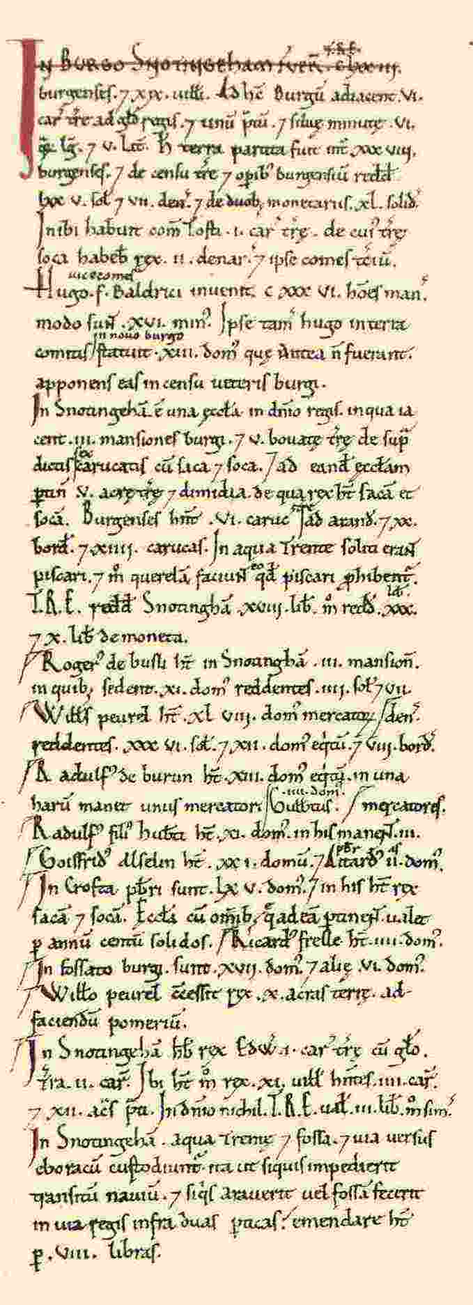
The
Domesday Book account of Nottingham comprises the whole of column f.280a of
volume I and, as is common form in circuit 6, it is enrolled before the breves of the county. Somewhat
anomalously, it is immediately followed by the description of the borough of
Derby, for in 1086, and probably for a long time before, the two counties had
been jointly administered.[2] The
customs of the two shires, a list of landholders, and the main body of the
Nottinghamshire text then follow in the usual way. The description of
the town exhibits a neat conceptual structure based upon three chronological
points of reference. The first two paragraphs relate to Nottingham in 1066, the
third to the state of the town when Hugh son of Baldric became sheriff and the
developments during his time in office, and the fourth to various interests at
the time of the Domesday Book and the value of the borough.[3] The
remainder of the account is devoted to the holders of land in Nottingham in
1086, with a note on roads and the River Trent.[4]
Despite
the apparent unity of the account, however, it was not all written at one time.
Different stages in its composition can be detected by variations in the hand
(figure 15). Entries no. 1, 4-10, 12-15, 17 and 18 were apparently written
first, but a space was left for nos. 2 and 3. These two entries are concerned
with the lands that Earl Tosti held in Nottingham before his expulsion from
office in 1065, and Hugh son of Baldric's activities as sheriff. Such foreseen
additions to the text are not unknown, especially in the terra regis. The phenomenon suggests that the scribe did not have the
required information before him in his exemplar, or was not sure of its import
or relevance, and only subsequently acquired it from a separate source.[5]
This would not be surprising in this context, for Earl Tosti's estate was
probably not part of the borough in 1066.[6]
Entries no. 11 and 16 are also post-scriptal, but were apparently unforeseen
additions for they are squeezed onto the last line of entries no. 10 and 15. It
may be significant that the houses belonged to the only individuals who were
not tenants-in-chief. Finally, entries nos. 19 and 20 appear to have been
appended to the end of the column, although not necessarily both at the same
time. No.19 relates to the one carucate of land which King Edward had in 1066
and which William held in 1086. In an urban context, the entry is anomolous,
for it is manorial in form and has a value for both 1066 and 1086. It appears
to be the same parcel of land that is enrolled in the king's breve as Notintone, that is Sneinton.[7] As
late as the thirteenth century there was still some doubt about the exact
status of the estate.[8] Entry
no. 20 is a note on the fines imposed upon those who encroached on the River
Trent in Nottingham,[9] the
dyke,[10]
and the road to York.
:
:
These
characteristics contrast with the discernible method employed in the breves. There were, of course
emendations and additions to each fief, but, by and large, the scribe of the
Exchequer text seems to have followed the form of an exemplar. Thus, no attempt
was made to reorganise the geographically arranged account of Roteland into the standard seigneurial
form. Compilation as such, then, was almost certainly complete before the
original returns were sent to Winchester.[11] It
was there that a fair copy alone was made, with some abbreviation of the
material, and the whole account was checked and revised. The source material
for the account of Nottingham, by way of contrast, appears to have been less
formulated, and the Exchequer scribe may have had to compile it himself.
Moreover, the record of data for three distinct periods contrasts starkly with
the form of the body of the text. In circuit 6, information is normally given
for 1066 and 1086. However, the approach in the borough is more consistent with
the articles recorded in the Inquisitio
Eliensis: data were to be collected for 1066, when William gave the land,
and the time of the survey.[12]
Whether these were the articles of the Domesday inquest, a composite collection
of articles, or a draft copy, is not absolutely clear,[13]
but it is evident that the account of Nottingham comes from a source other than
that of the breves, or from an
earlier stage in the enquiry. It is only in the terra regis that comparable characteristics are found,[14]
and it is therefore possible that the material is derived from an initial
survey of royal land alone.[15] The
separate treatment of the borough, then, may not be entirely a result of its
separate nature and functions.[16] It
may also be a function of the source material that the Domesday scribe had
before him. Deriving the information from a source other than that of the breves, as a copyist, he made no attempt
to rearrange it in the form of the text as a whole. With only the minimum of
compilation to make it comprehensible, he simply enrolled the borough in a
separate section.
There
is little explicit information in the text to elucidate the nature of tenure
and its different forms in the borough of Nottingham. The king and the earl
enjoyed the soke of Earl Tosti's carucate of land, and there is evidence for an
old and a new borough. The king also had sake and soke over the land of the
church.[17]
Important evidence, however, is provided by the structure of the account. The
subject matter is divided into two distinct sections, one of which is
emphasised by the use of a distinctive calligraphic device. The first is a
general description of the borough and concludes with a record of how much
Nottingham rendered to the king in 1066 and 1086.[18]
The second consists almost entirely of a description of the land of named
individuals, six of whom were tenants-in-chief, in addition to land of the king
and houses in the town ditch. With the exception of the last, postscriptal
entry, each entry in the section is distinguished by a flag in the left-hand
margin. This bi-partite form is common in the description of the Domesday
boroughs: it is found in the account of Derby where the two parts were
originally separated by a space. It was subsequently employed, however, to
enroll an account of the manor of Litchurch which rendered with the borough.[19]
The accounts of Stamford, Lincoln, York, and Huntingdon, in common with those
of county boroughs in other circuits, are similarly divided.[20]
Each
of the two sections has a distinctive identity. It is clear that the first is
concerned with the income that the king derived from the borough for no other
interested party is named. In 1066 there were 173 burgesses and 19 villeins in
Nottingham. By 1086, there were only 120 men, but 13 houses had been built in
the new borough which had been placed in the farm (census) of the old.[21] But
the nature of the relationship between the king and the burgesses is not
explicit. In the comparable section of the account of the borough of Derby,
however, it is said that the king has two pennies, and the earl the third,
from the gable, toll, forfeitures, and
all customs of the burgesses.[22] A
study of the Domesday boroughs in circuit 6 suggests that the term consuetudo or consuetudines, custom or customs, lies at the heart of the matter.
In Stamford, for example, it is stated that the mansiones in the first section rendered all customs.[23]
It is nowhere stated in what these dues consisted, but the term seems to be a
portmanteau word for all those exactions that the king might expect from the
inhabitants of a town. Some of them, however, can be discerned from the record
of the partial immunities recorded in the text. The sixth ward of Stamford paid
all custom except toll and landgable, Lewin held all custom except geld, and
Queen Edith had every custom except those relating to baking.[24]
From elsewhere in Domesday Book, it is clear that forfeitures, heriot, local
monetary dues for military service, ward duty, and even personal services like
carriage and custody of prisoners were also included.[25]
It is clear that only these townspeople who paid custom contributed to the farm
of the town. Thus, in the Domesday accounts of both Nottingham and Derby the
value of the borough is given at the end of the customary section.[26]
In this sense, it was they alone who were burgesses of the community, although
the term was used of other inhabitants of the town.[27]
Since the king and the earl received their forfeitures, it is evident that they
were in the soke of the crown. If their status was analogous to that of royal
sokemen, so was their tenure for the
legal form of customary land was much the same as that of sokeland of
the terra regis. As we have already
seen,[28]
the term consuetudines appears to be
synonymous with the dues rendered to the king from land in the soke of
Oswaldbeck. There were, moreover, remarkable similarities in the customs of
tenure. Thus, ultimogeniture, a feature of socage tenure in many manors in the
county, is also found in the English borough in Nottingham.[29]
The relationship was of a similar tributary kind, although the actual dues
rendered often differed considerably.[30] The
burgess of the eleventh century, then, if only in legal form, shared many
characteristics with the rural sokeman.
In
the second section of the Nottingham text, 191 houses are recorded which were
held by nine named individuals, one of whom was the king. Twenty five are said
to be horsemen's houses (domus equitum)
and 48 merchants' (domus mercatorum).
There were a further 23 houses of which no further details of tenure are given.[31]
The inclusion of royal land suggests that the section has some distinctive
identity. The dues of the crown appear in the first section, yet land of the
church over which the king has sake and soke is separately recorded. Indeed,
the note of the value of the estate indicates a tenurial nexus other than that
of the borough.[32]
That this is a general characteristic of
the group is illustrated by the appearance of a flag in the left-hand
margin against each entry. Such apparently trivial devices are rarely ad hoc. They are usually used
consistently and for a specific purpose. The flag is no exception. It appears
within the text as an overflow mark, that is, when one entry is continued in an
empty space on the line above or below. The marginal variety is found in the Clamores in Lincolnshire,
Huntingdonshire, and Yorkshire where it indicates separate cases.[33]
In the breves it is less common, but
is used to call attention to exceptional or additional material.[34]
It is more commonly encountered, however, in the description of boroughs. It
usually does not appear against customary land, but only that held by named
individuals who enjoyed considerable liberties. Thus, in Stamford the flag is
found against those entries where the lord did not pay all customs.[35]
In Derby it is used consistently in every entry in the second section with the
exception of one parcel of land from part of which the king derived an income.[36]
But, significantly, the flag is also used against customary tenements in
Huntingdon which were vacant.[37] This
characteristic points to the essential function of the device when not used as
a mere annotation. It is clearly intended to show that the king, for whatever
reason, did not expect any issues from the properties noted. Since the value of
the borough appears at the end of the first section, it would appear that the
second part of the description of Nottingham, as with the same section in other
boroughs is merely a memorandum which
defines the limits of the king's interests.[38] In
the lands of the tenants-in-chief, it was usually the lord's liberty which
circumscribed the interests of the crown within the borough. In Derby,
Huntingdon, and Lincoln, as in the one explicit instance in Nottingham, the
nature of the immunity is expressed by the term sake and soke.[39]
The franchise, it seems, amounts to freedom from custom. Thus, in Huntingdon
'Earl Siward had one messuage with sake and soke exempt from custom'.[40]
In Lincoln, Countess Judith had a messuage in succession to Stori without sake
and soke, and this was evidently customary for Ivo Taillebois claimed it
through the burgesses, that is as part of the borough.[41]
The liberty of sake and soke, by conferring full title to the land and all the
dues that the king might expect from it, transferred consuetudines from the crown to a lord. This, then, would appear to
be the basic feature of the mansiones
of the tenants-in-chief in the second section. The land was not part of the
borough from which the king expected
dues, but was booked to other interests. The fundamental dichotomy between the
two sections is indeed recognised in the description of Nottingham. As we have
seen, the account of the church appears in two separate entries. Although it
was the king's demesne, it possessed 'three mansiones
of the borough', along with land which may also have been customary.[42]
It is therefore appropriate that the fact should be recorded in the account of
the borough proper, that is the first section. By way of contrast, the priest's
croft with 65 houses was held with sake and soke and was thus not 'of the
borough'.[43]
It therefore appears in the second section. As already noted, the separate value points to a distinct tenurial nexus other than
the borough. The church thus appears in both sections because it held customary
and non-customary land. It seems likely that all the land of the tenants-in-chief
recorded in the Nottingham Domesday was non-customary in the same way.
The
possession of sake and soke appears to have conferred a degree of independence
upon the privileged estate within the borough. As with the booking of sokeland,
the tenants were removed from certain aspects of royal administration. The
characteristics of the liberties in urban context are illustrated by the
subsequent history of such lands in the twelfth and thirteenth centuries.
Typically, where such tenements survived, they constituted a separate fee
within the borough. The best documented example in the area of the Five
Boroughs is the 23 houses and two churches that Eudo Dapifer held in Stamford
in succession to Ernuin the priest and Ezi.[44] The
customs of the estate had only been withdrawn from the king between 1066 and
1086. But in 1156, the estate was held by William de Lanvalei and was expressly
excluded from the grant of the borough of Stamford to Richard Humet.[45]
In 1212, it was said to be held in chief of the king by free burgage.[46]
As such, it was exempt from tallages levied on the town, despite the attempts
of the burgesses to impose the incident.[47] In
1275, the lord, John de Burgh, had a free court in the town, with the assize of
bread and ale, and possibly a pillory. That he exercised these rights is indicated
by the complaint that the bailiffs of the Earl of Warenne, the lord
of Stamford, illegally demanded
suit of his tenants.[48] In
1284 a jury declared that the estate was a parcel of his manor of Wakerley in
Northamptonshire.[49]
Nevertheless, the lord still had to pay suit twice a year to the borough court.[50]
Eudo's
fee was large and managed to retain its identity into the fifteenth century.
The evidence for its existence survived because, as an integral part of a rural
manor, it repeatedly appears in extents in the process of successive
inquisitions post mortem. By way of
contrast, where such fees were, or became, purely urban, documentation does not
always survive. In Nottingham, however, there is evidence that some of the non-customary
estates maintained their identity into the later Middle Ages. In Henry's II's
charter of liberties of c.1155 the
men of all fees in Nottingham were enjoined to pay tallages with the burgesses.[51]
Sneinton emerged in the thirteenth century as a manor in ancient demesne,
although it was by then outside the borough.[52] Some
of these fees, although absent from the predominantly official and burghal
documentation, may have been subject to private courts. In 1219, Gilbert le
Gluton held land and an oven in Nottingham by sergeancy as a royal bailiff
errant.[53]
The fee was held in chief, and was probably quite extensive. A case brought
against Gilbert in the curia regis in
1225 by William son of Simon sought the seisin of seven crofts and
half an oven in Nottingham.[54]
Subsequently, it was described as tenements, and later a messuage, with an
oven.[55]
Part of the fee may have been situated in the Saturday Market for John son of Geoffrey le Gaoler, who was
granted the estate in 1306, held at least one toft there within the English
Borough.[56]
But the oven was probably located off Wheeler Gate, possibly in the present
Eldon Chambers, for in 1395/6 a tenement on that street was said to abut on a
common lane (venella) leading to
Gilbert le Gluton's oven.[57] The
fee can be traced into the late fourteenth century, and throughout the
possession of an oven or bakehouse is usually carefully noted.[58]
As a capital tenement, this might imply that Gilbert and his successors had the
assize of bread. He was probably not alone in possessing this type of
franchise. In a document of 1370 or 1378, some 12 individuals with tenements
spread throughout the western part of the town, are said to have not been
within the mayor's liberty of the assize of ale in Nottingham.[59]
As we have already seen,[60] the
assizes were one of the perquisites of a private urban court, and the
corporation clearly did not have a monopoly in this field. Evidence for the
earlier history of Gilbert le Gluton's fee is wanting. But the assizes were
part of the borough customs in the eleventh century, and it is possible that it
is represented by the estate of Wulfbert or
Richard Frail at the time of Domesday Book.[61]
In only one case, however, has positive evidence for a private court come to
light. In 1276 an inquisition post mortem
jury declared that certain tenants of William Bardolf in Nottingham and
elsewhere rendered 49 shillings 4 pence per annum and one pound of cumin, and
owed suit to his court in Shelford.[62] No
other evidence for this fee has come to light, although Robert de Cauz the lord
of Shelford granted a messuage between the castle and the Trent to Newstead
Priory in the late twelfth century.[63] But
the association between the manor and the town appears to have been ancient for
Geoffrey Alselin, the lord in 1086, held 21 houses in Nottingham at the time of
Domesday Book.[64]
The Domesday tenements held with sake and soke
are not a homogeneous group. Circuit 6 reveals a variety of different types of
estate: urban sokes, land, presumably legally, withdrawn from the king's
customs, ecclesiastical liberties etc..[65] But
the most common is akin to the Shelford example. The type of relationship is
referred to in the Cheshire Domesday:
The land on which St. Peter's Temple stands and
which Robert of Rhuddlan claimed as thaneland, never belonged to a manor
outside of the city (of Chester), as the county proved, but belonged to the
borough, and was always in the king's and the earl's customary dues like the
land of the other burgesses.[66]
Almost all the mansiones
of the tenants-in-chief in the circuit 6 boroughs appear to be of the type that
were attached to manors in the countryside. Since they did not render to the
king, the custom was presumably paid to the lord. Moreover, it is clear that
the tenurial nexus was not in the borough itself. Urban fees of this kind, like
the bishop of Lincoln's manor in Leicester, or Queen Edith's fee in Stamford,
usually have a value appended to them if held by a tenant-in-chief.[67]
On the contrary, the absence of a value for most urban estates in Domesday Book
tends to suggest that the tenurial nexus was elsewhere, that is, the value of
the manor also included the value of its urban appurtenances.[68]
Nottingham
is no exception in this respect. Only the church has a separate value,[69]
thereby suggesting that it alone was a purely urban and self-contained fee.
There are features of the account, however, which are unusual. The Nottingham
text is the only description of a Domesday borough in circuit 6 in which the
pre-Conquest holders of land are not generally given. The information is
usually recorded for it not only established title, but also identified the
tenement. It incidentally also establishes that many of the links between urban
fees and rural estates were pre-Conquest in origin. The absence of the data in
Nottingham may be symptomatic of significant differences in the early
development of the town. There are indeed several characteristics which suggest
that Nottingham experienced a number of pressures which were not present in
other county boroughs.
In
1086 the town was divided into what were subsequently known as the English and
the French boroughs. Throughout the Middle Ages the two institutions had
distinctive identities marked by individual customs and separate
administration.[70]
As the name suggests, the English borough qua
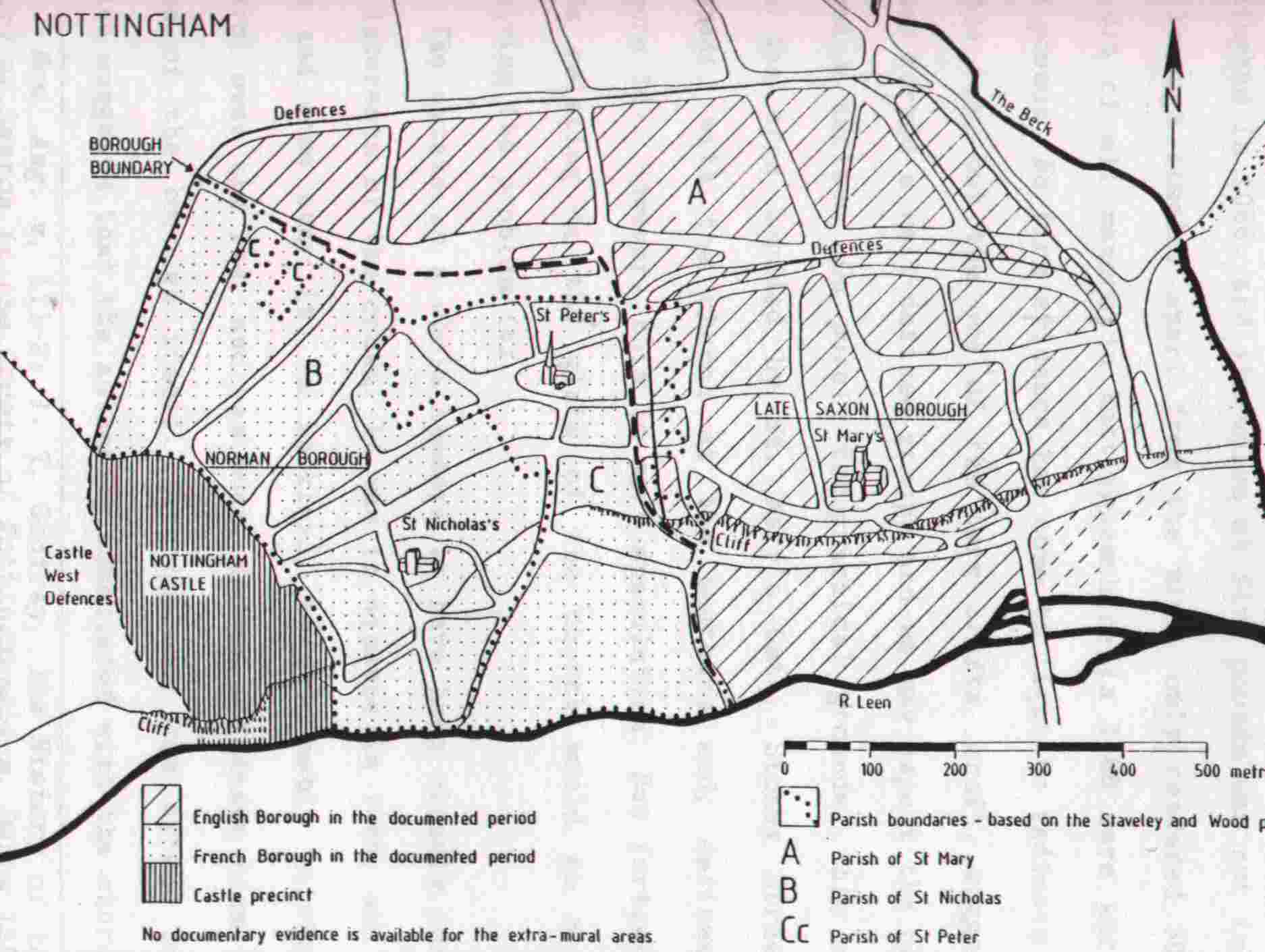
borough was the more ancient. Its area in the later mediaeval period (figure
16) has been elegantly elucidated by the use of mostly late mediaeval and early
modern property deeds and quarter session minutes.[71]
There is no comparable evidence for the earlier period. But the decisive
relationship, the boundary between the two boroughs, is probably an ancient
feature. Peculiarities of custom and tenure imply continuity, and the
conjunction of the line for much of its course with the St. Mary/St. Peter
parish boundary suggests that there had been no substantial change since the
establishment of the parochial system as a territorial institution before the
mid twelfth century.[72] The
borough so identified as a legal entity encompassed the pre-Conquest defended
area, and abutted on the Saturday Market. With the exception of a few tenements
on the east side of Bridlesmith Gate, it was almost exactly co-extensive with
the urban parish of St. Mary.
As we
have already seen,[73] the
king had sake and soke over a large urban estate which consisted of a church
and the priest's croft, containing some 65 houses, and held a further three
customary mansiones and land in the
fields, which were all worth 100 shillings per annum.[74]
Although not named, it is clear from the history of the foundation that this
church was St Mary's, for the crown maintained a continuing interest in it.
Thus, in c.1106, William Peverel
granted the church to his new monastery at Lenton as part of
its endowment. However, he only did so with the express consent of Henry I.[75]
In the thirteenth century Henry III challenged the priory's right to the
church, although he granted it to them for the term of his life.[76]
By way of contrast, the king appears to have had no interest in the churches of
the French borough. The fee of the church is the largest recorded estate in
Nottingham in 1066, and its value at five pounds was not inconsiderable. The
borough itself, apart from the mint, only rendered 30 pounds,[77]
and 91% of all manors in Nottinghamshire in 1086 were worth less than five
pounds. No firm evidence has come to light to indicate the location of the fee,
but the use of the term crofta,
croft, suggests that the houses formed a well-defined group, and we may expect
the church to have formed a nucleus. On purely topographical grounds, this
might suggest that the area bounded by St. Mary's Gate, Stoney Street, and High
Pavement, with the church at the southern end, defines the estate (figure 16).
However, this is mere speculation. But further work on the deeds relating to
the glebe of the church would go a long way to resolving the problem.[78]
:
The
simplicity of ecclesiastical structure is striking. By the end of the tenth and
the beginning of the eleventh centuries, one of the key characteristics of
bookland was the appropriation of ecclesiastical dues. Thanes increasingly
began to build churches on their own land as much to enjoy the tithe as to
bring spiritual sustenance to their men.[82]
Within the confines of the borough, the process led to a proliferation of
parishes as each lord made provision for his own tenants. Thus, the Domesday
account of Derby records six churches, four of which were on non-customary
land.[83]
In other boroughs and cities, churches multiplied without constraint. By 1200
there were thirteen in Stamford, while in Lincoln there were no less than 43 by
c. 1150.[84]
Nottingham, then, stands out as exceptional. Despite apparent tenurial heterogeneity
in 1086, much of the borough was in the parish of a royal church, and the
number of parishes in the Middle Ages never exceeded three or possibly four.[85]
The lack of development of other churches may suggest, then, that the freedom
of potential or actual non-customary fees was circumscribed. Either they did
not emerge in the borough until after the establishment of a stable parochial
system, or royal control limited the rights of any fees to found their own
church.[86]
In either case, the authority and influence of the crown within the borough of
Nottingham is emphasised.
The
concentration of royal authority in the town is probably an ancient feature of
the settlement.[87]
Its association with a major parish church implies that St. Mary's was an
ecclesiastical foundation of primary importance. Some claims can indeed be made
for its antiquity. Excavations in the town have revealed traces of a ditch
system which, if extended, would enclose the church on the north side. This
system, parallel to, but to the north of, the later defences, extended down
towards the present course of the Leen, and is stratigraphically earlier than
the ramparts of the English Borough.[88]
If part of the complex, the parish
church, then, would be one of the earliest identifiable topographical features
of the settlement. It might be expected that such an early foundation,
especially if royal, had been constituted as a royal minster with a large parochia. Comparable institutions are to
be found in Derby, Leicester, and Lincoln,[89] but
no unequivocal vestige of such an organisation has come to light in Nottingham.[90]
The lack of evidence, however, may merely reflect the subsequent history of the
church. Its appropriation by Lenton Priory, along with many other churches of
the Peverel fee, may have obscured early relationships for it is usually
impossible to determine whether thirteenth-century pensions were derived from
the ancient rights of a particular foundation or more recent arrangements for
the financial management of a house's spiritualities.[91]
The origin and early status of St. Mary's Church, Nottingham, then, must remain
an open question.
The
two parishes of St. Peter and St. Nicholas are situated between the
extra-parochial castle and the urban part of St. Mary's parish. They are both
small in area and almost entirely urban, and are surrounded by the parish of
St. Mary's. With no share in the common
fields of the town, it seems likely that they are
relatively late foundations, and took their territory from the larger church.[92]
It is not surprising, then, that, with the exception of tenements on the east
side of Bridle-smith Gate and possibly the south side of the Saturday Market,
they are conterminous with the area of the French Borough of the later Middle
Ages (figure 16). The new borough is first mentioned in Domesday Book, and, as
its name indicates, it was an institution which was closely associated with the
Norman presence in the town. The castle of Nottingham was built by William the
Conqueror in 1068 at the beginning of his campaign in the North as part of a
concerted strategy of garrisoning centres of population in a potentially
hostile Mercia and securing the main lines of communication with Yorkshire.[93]
As at Norwich and Northampton, a French borough was probably founded at the same
time.[94]
The present Castle Gate, Hounds Gate, and Friar Lane appear to be planned in
relation to the eastern gate of the castle, and probably form the nucleus of
the borough.
It is
unlikely, however, that it was built on a virgin site. Rather, it almost
certainly encompassed a pre-Conquest estate nucleus of some importance.
Superficially the Domesday passage which refers to the new borough, appears to
indicate a new settlement for Hugh son of Baldric built 13 houses in the new
borough which were not there before. However in novo burgo is a interlineation and it is thus clear that it is
parenthetical. The whole passage can be rendered thus, with the later additions
in brackets:-
Hugh son of Baldric [the sheriff] found 136
men; now there are 16 less; however, Hugh erected 13 houses himself, which were
not there before, on the earl's land [in the new borough] and placed them among
the dues of the old borough.[95]
In this reading, the contrast is not between new and old
boroughs, but between the earl's land and the old borough. The two institutions
were distinct. Indeed, as we have seen,[96]
entries no. B2 and 3, in which reference is made to the earl's land, are later
additions, and are almost certainly drawn from a source other than that of the
body of the text, for at least one of the entries refers to a period anterior
to 1065 when Tosti was disposed. It was therefore necessary to note that the
new houses, which ought to have been in the earl's soke, contributed to the
king's custom and were consequently in the old borough. By implication, this
tends to suggest that there were already other houses there. The earl in
question is evidently Tosti, and the land the one carucate he held before the
Conquest. This estate was clearly royal, or possibly comital, for both the king
and the earl had the soke.[97]
Tosti probably held it as Earl of Northumbria for in the later years of the
reign of Edward the Confessor, Nottinghamshire appears to have been part of the
earldom.[98]
Thus, while the French borough was evidently built on the earl's land, there
was already an estate nucleus there before the Conquest.
Tosti's
activities in the shire are shrouded in obscurity. It is therefore difficult to
appreciate the nature and function of this estate and its relationship with the
borough and the other estates
in the county. However, in
extent it was probably not confirmed to Nottingham, but may have extended into
the neighbouring territory of Lenton (figure 17). In 1086 there were
three holdings in
the settlement. William Peverel's soke had belonged to
Morcar's manor of Newbound in the wapentake of Broxtow, or Earl Morcar's manor
of Newbold in Bingham. The identification is difficult, but the wapentake
sequence of the breve suggests that
the former should be preferred.[99] The
Morcar who held this manor was almost certainly Earl Morcar - he is not always given his title in Domesday Book,
but when it appears in circuit 6, it is always interlined - who succeeded to
Tosti's earldom in 1065.[100] If
a comital estate, some connection with Tosti's land in Nottingham might be
expected. Wulfnoth's manor may also have been attached to the estate. He
himself was the tenant in both 1066 and 1086, but William Peverel held the land
in custody. Three other estates are said to have been held in likewise by
William.[101]
Ulfketel's land in Eastwood and Alwin's in Awsworth were waste and untenanted.
The description of Aswulf's land in Basford was deleted, but is duplicated
later in William's breve, and a
second time in the land of the king's thanes.[102]
Land held by William Peverel in Clifton and Sutton Passeys is also duplicated
in the same way.[103] It
is evident, then, that the land held
in custody was
that of thanes who, in the
normal course of events, would have owed service to the king or the earl. As in
Derbyshire,[104]
William represented many of the interests of the king in Nottinghamshire.
Wulfnoth, then, may well have been one of Tosti's Nottinghamshire thanes to
whom Edward the Confessor addressed a writ in 1060x1065.[105]
:
:
|
REF |
ASSESS |
STATUS OF LAND |
TRE HOLDER |
TRW HOLDER |
|
c. b. |
|
|
|
|
1,48 |
4 |
soke of Arnold |
King Edward |
the king |
|
10,19 |
2 0 |
soke of Neubold |
Morcar |
Peverel |
|
10,24 |
4 |
Manor |
Wulfnoth |
Wulfnoth |
:
Contrary
to what one would expect in that case, however, the honour, did not meet in
Clifton in the Middle Ages. From at least the twelfth century, the court was
held in Nottingham.[113] But
significantly it probably did not meet in the castle. It is recorded in an
early four-tenth century assize roll that the king's court in the fee of
Peverel used to be held in the chapel of St. James in Nottingham until it was
enclosed in 1316 by the Carmelite Friars, and the king's bailiffs of the fee
could no longer hold court there.[114] No
earlier evidence than this has come to light. But the Peverel fee escheated to
the crown in c.1154 and was farmed as
a royal estate from that time.[115] It
is difficult to understand in what circumstances its court could have been
moved from a royal castle into a borough during that period. The association
with St. James chapel, then, has every sign of being an ancient traditional
meeting place. Moreover, it was not the only institution that met there, or in
the vicinity. There is also evidence that the county court was also held in the
same area.[116]
The site of the chapel can be precisely identified. It stood close to the
significantly named Moothallgate, the present Friar Lane, within the French
borough.[117]
As we
have already seen,[118] this
was part of the earl's estate before the Conquest. Although the fact is not
stated in Domesday Book, it seems very likely that William Peverel held the
estate as part of his honour, for the French Borough was very closely
associated with the fee in the twelfth century. Thus, in the foundation charter
of Lenton, William granted the monks the churches of St. Nicholas and St.
Peter, apparently as part of his own fee. By way of contrast, he sought the
consent of Henry I for the alienation of the church of St. Mary in the English
borough.[119]
This implies a more demesnal interest in the French Borough compared with the
English. Moreover, local tradition claims that the whole of Nottingham fell
within the jurisdiction of the Peverel court until 1316 when St, James' Chapel
was appropriated by the Friars.[120] No
mediaeval authority has been found for this statement, and, as it stands, it
cannot be true. The English borough was royal, and had its own court from at
least the time of its first charter granted in c.1155.[121] But
part of the town may have paid suit to the honorial court. Contrary to the
accepted opinion, it seems unlikely that the c.1155 charter refers to both the French and English boroughs. The
construction of one defensive circuit around the two suggests that there was,
in some respects, a single community by the middle of the twelfth century.[122]
But it is clear from a charter granted to the burgesses of Nottingham by Earl
John in c.1189 that Henry II's
liberties only granted a single reeve: henceforward the burgesses were to elect
this officer, although John had the right of veto.[123]
However, from 1200 there is evidence for two
reeves and, by 1230, four, two for each of the boroughs.[124] Some
degree of separation of administration is implied. Indeed, an assize of
bread made in 1248 was confined to the English borough for it was witnessed by
the bailiffs of that borough alone.[125] The
French Borough evidently had its own assize. Such fragmentation of
administration is unlikely to have developed if the one reeve of c.1155 and c.1189 had jurisdiction over both boroughs. As late as the 1280s,
the French borough was separately farmed for in a pre-1284 charter a tenement
on the west side of Bridlesmith Gate paid 3d to 'the farm of the king in the
French Borough'.[126] It
was not until 1284 that the two boroughs were united under one mayor.[127]
If,
then, the French Borough remained separate from the English Borough, it may
well have paid suit to the Peverel court. Indeed. it was probably perquisites
of this court that were escheated in the late twelfth century after Earl John
forfeited Nottingham and the shire, along with the Peverel fee. In the 1194
Pipe Roll the sheriff accounted for 18 shillings and 7 pence rent (census) from 'very many houses in the
vill of Nottingham', and 3 shillings from the toft of the moneyers and 2
shillings from their houses, under the heading of 'fines made for the knights
and men of Earl John'. In subsequent years, the sums recorded were 23 shillings
and 6 pence and 5 shillings, and are called 'purpresture and escheats'.[128]
Census in this context probably
implies landgable and/or farm, but the fee was evidently not part of the
English Borough which was farmed by the burgesses. It is therefore probable
that the escheated estate was located within the
French Borough. In
its essentials, the new borough was almost certainly a seigneurial
institution within the honour of Peverel.
In
the light of the English characteristics of much of William Peverel's fee, its relationship
with the the site of the French Borough, that is, the earl's estate, may also
have had a pre-Conquest origin. Some connection there must have been, for it is
inconceivable that Tosti could have controlled Nottingham without holding
Clifton and the other estates of the fee. As early as the beginning of the
tenth century, the need to control the southern approaches and the river had
been recognised, for in 920 Edward the Elder built a borough to the south of
the Trent.[129]
Although there is no evidence that this structure survived into the eleventh
century, West Bridgford, its most likely site, was situated within the manor of
Clifton.[130]
There is no reason to suppose that the strategic importance of the area was any
less important in 1066.[131]
Unfortunately, almost nothing is known about William's likely predecessor,
Countess Gytha, the lady of the manor in 1066, and her place in the power
structures in the county. She was the wife of Earl Ralf of Hereford, Edward the
Confessor's nephew, and they had a son called Harold. After Ralf's death in
1056, the earldom was given to Harold Godwinson, but nothing is known
about Gytha's subsequent activities.[132]
It is possible that she was in some way related to the house of Godwin, and
therefore Tosti, for the two families shared the names Gytha and Harold. Such
patterns are often characteristic of kinship groups. It is more likely, though,
that she benefited directly or
indirectly, from the overthrow of Tosti in 1065 for she apparently held lands
in Northamptonshire, Bedfordshire and Nottinghamshire, the earldoms of which
had both been held by the earl, in the following year.[133]
It is therefore possible that she also held Tosti's land in Nottingham in 1066
as the caput of her Nottinghamshire
estates. The fact, of course, is apparently contested by Domesday Book. But
information for the earl's carucate in Nottingham evidently came from a source
drawn up before 1065 when he was deposed.[134] The
datum for the account of Clifton, however, in common with the rest of the
survey, was ostensibly 1066. The disparity in the Domesday Book, then, may
merely reflect the use of different sources. Ultimately, however, it is not
possible to penetrate the obscurity of the subject and period. Nevertheless,
Domesday Book provides evidence of a remarkable concentration of lands of
thanes around Nottingham in 1066. The pattern is unusual, although probably not
unparalleled, and is evidently related to the town. There remains the
possibility, then, though probably unproveable, that Tosti's estate was the
centre of a pre-Conquest group of manors which was related to the defence of
Nottingham which passed en bloc to
William Peverel after the Conquest.
Such,
then, is the context in which the French borough was founded. Far from being a
new settlement, it was a re-organisation of a royal or comital estate which was
situated adjacent to, but administratively separate from, the pre-Conquest
borough. Despite considerable uncertainty about the function of this estate, as
Earl Tosti's land, it was evidently of
some importance in the borough and the county. Some-thing of its form may have
survived in the character of the French borough. The reorganisation was in many
ways radical. If part of the estate, the appurtenant land in Lenton was
appended to other manors, and the element in Nottingham was urbanised. The
nineteen villeins in 1066 probably belonged to this estate rather than the
borough, and are recorded because their land was subsequently absorbed in the
new town.[135]
Burgage tenure and French customs, such as primogeniture, were probably
introduced at this time. The process is not unparalleled. At Stamford, part of
the royal estate adjacent to the Anglo-Scandinavian borough was incorporated
into the town when the castle was built on the site. The agricultural element
of the estate, however, was appended to a royal manor in Ketton or Great
Casterton to the west of the town.[136]
Nevertheless, the French Borough was probably seigneurial rather than royal in
character, or rapidly became so. Its role as the centre of the Peverel fee in
the fourteenth century may reflect a pre-Conquest arrangement of estates which
were organised through the earl's estate to defend the borough. The building of
the castle on the rock and Standard Hill may, then, represent continuity of
institution, if not of site, from the pre- to post-Conquest period. Something
of the pre-Conquest layout of the estate may also have survived. Clearly the
Saturday Market is not necessarily a function of the relationship between the
two boroughs. As at Stamford, it may be an early topographical feature which
owes as much to the presence of the extra-burghal estate as of the borough.[137]
There may also be grounds for seeing
St. Peter's as a
market church. The parish of St. Nicholas more or less defines the area in
which the streets fan out from the castle. This may be the original extent of
the French borough. St. Peter's parish however is squeezed in between this area
and the English borough. In the documented period it did not encompass the
market, but its area may have been considerably infilled. Such speculations,
however, can only be resolved by further archaeological research.
In 1066, then,
Nottingham was a complex settlement which was characterised by three
distinctive features. First, royal authority within the borough was more
pronounced than in most county towns. Second, there was a royal or comital
estate adjacent to the borough but administratively distinct from it. Third, a
large number of thanes settled within the vicinity appear to be related to the
defence of the town and were probably organised through this estate. It is
within this context that the fees recorded in the second section of the
Domesday account must be examined. As has already been seen, many of these
tenements probably belonged to rural estates and were certainly responsible for
a degree of tenurial heterogeneity in the later Middle Ages. Elsewhere such
fees were common before the Conquest, and were related to the specialised
functions of the borough as a social, economic, and military centre. But in
Nottingham there is no evidence that they were a pre-Conquest feature of the
town for no TRE tenants are named in the Domesday account. An argument from
silence is, of course, dangerous, but the absence of the information, coupled
with the simplicity of the parochial structure in Nottingham, tends to suggest
that the fees were a Norman innovation. Indeed, the record of domus equitum, houses of horsemen or
knights, may imply that they are directly related to the garrisoning of the
castle, and owe their existence to the reorganisation of Earl Tosti's estate.[138]
This is not to say that the lords of the shire did not hold tenements in the
borough before the Conquest. They almost certainly did. But they were probably
not held with sake and soke and were thus not part of their manors but belonged
to the borough and therefore appear in the first section of the account.[139]
The existence of such liberties in the boroughs may betoken something more than
a mere economic function for they carried with them the reciprocal duties of
army service, repair of bridges, and the garrisoning of the fortresses.[140]
Although the garrison theory as a general interpretation of the origins of
boroughs has been discredited, nevertheless boroughs were still manned and
bookland was burdened with the duty.[141] In
Nottingham, however, the booking of land was a late development for defence was
probably the direct responsibility of the earl and the thanes settled around
the borough. There was, then, probably no need for non-customary tenements
within the borough.